|
|
ABOUT WATERSHEDS What is a Watershed?
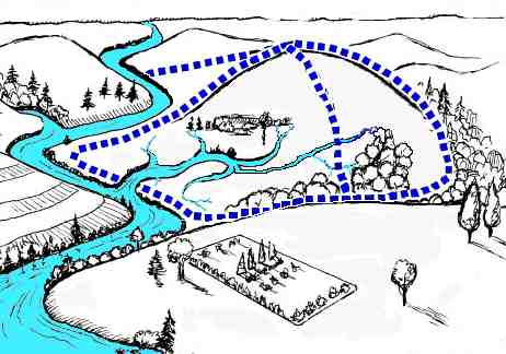
A watershed, also called a drainage basin, is the
area in which all water, sediments, and dissolved
materials flow or drain from the land into a common
river, lake, ocean, or other body of water. top
Why are Watersheds Important?
Watersheds are the link between land and water
resources. A watershed approach to conservation and
development of resources addresses, not only water
resources, but also the surrounding land from which the
water drains.
top
What is Watershed Management?
Watershed management is a program to conserve and develop
local natural resources. It is most effective
when coordinating with other resource management
programs, including other surface and ground-water
protection programs, flood control, water supply,
protection of fish and wildlife, recreation, control of
stormwater, and nonpoint source pollution, and economic
development.
top

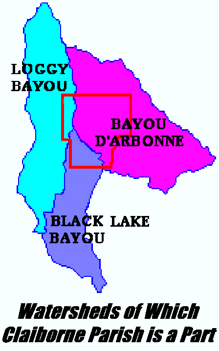
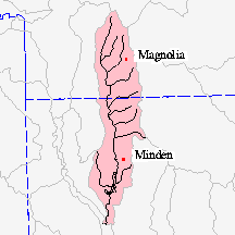
CLAIBORNE PARISH’S
WATERSHEDS (Claiborne
Watersheds and Its Protection Poster)
Claiborne Parish is part of Three Watersheds
(figure at top right of this page):
top

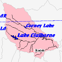
SURF
YOUR WATERSHED (Claiborne Parish)
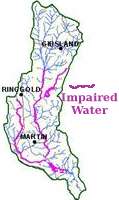
Water
Quality Reports for D'Arbonne Tributaries: Summary
In accordance with Section 106 of the federal Clean Water
Act and under the authority of the Louisiana
Environmental Quality Act, the LDEQ has established a
comprehensive program for monitoring the quality of the
state’s surface waters. The objectives are to
determine the quality of the state’s surface waters,
to develop a long-term data base for water quality trend
analysis, and to monitor the effectiveness of pollution
controls. The data obtained through the surface water
monitoring program is used to develop the state’s
biennial 305(b) report (Water Quality Inventory) and the
303(d) list of impaired waters. This information is also
utilized in establishing priorities for the LDEQ nonpoint
source program.
LDEQ has implemented a watershed approach to surface
water quality monitoring. Through this approach, the
entire state is sampled over a five-year cycle with two
targeted basins sampled each year. This report presents
the results of a watershed based, calibrated modeling
analysis of the tributaries to Bayou D’Arbonne Lake.
As the monitoring results are evaluated at the end of
each year, waterbodies may be added to or removed from
the 303(d) list. The calibration models’ input data
sources were July 2001 intensive survey data and data
collected elsewhere by LDEQ, USGS, municipal discharge
records, and other sources. The Louisiana Total
Maximum Daily Load Technical Procedures, 05/22/2001, have
been followed in this study.
Modeling was limited to low flow scenarios for both the
calibration and the projections since the constituent of
concern was dissolved oxygen and the available data was
limited to low flow.
Both LDEQ's 1998 303(d) list and EPA’s 2000 Modified
Court Ordered 303(d) list cited the three tributaries to
Bayou D’Arbonne Lake (subsegments 080603, 080609,
and 080610) as being impaired. The suspected cause was
organic enrichment/low DO and the suspected sources were
"natural sources" and "unknown
source". These three subsegments were subsequently
scheduled for TMDL development with other listed waters
in the Ouachita River basin. This TMDL addresses the
organic enrichment/low DO impairment.
| Bayou
D'Arbonne-Headwaters to Lake Claiborne |
LA080601_00 |
| Overall
Use Support |
Partial |
| Water
Body Type: River |
Water
Body Size: 20 miles |
| 1999
Court Ordered 303(d) List:
NO |
When
Assessed: 2000 |
| Designated
Uses |
Support |
| Drinking
Water Supply |
Fully |
| Primary
Contact Recreation |
Not
Supporting |
| Secondary
Contact Recreation |
Fully |
| Fish
and Wildlife Propagation |
Not
Supporting |
| Suspected
Causes of Impairment |
Salinity/TDS/chlorides,
Sulfates |
| Suspected
Sources of Impairment |
Silviculture,
Municipal Point Sources, Agriculture |
| Bayou
D'Arbonne- Lake Claiborne |
LA080602_00 |
| Overall
Use Support |
Fully |
| Water
Body Type: Fresh Water Lake |
Water
Body Size: 6400 Acres |
| 1999
Court Ordered 303(d) List:
NO |
When
Assessed: 2000 |
| Designated
Uses |
Support |
| Drinking
Water Supply |
Fully |
| Primary
Contact Recreation |
Fully |
| Secondary
Contact Recreation |
Fully |
| Fish
and Wildlife Propagation |
Fully |
| Suspected
Causes of Impairment |
No
Records Found |
| Suspected
Sources of Impairment |
No
Records Found |
| Bayou
D'Arbonne- From Lake Claiborne to Bayou D'Arbonne
Lake |
LA080603_00 |
| Overall
Use Support |
Fully |
| Water
Body Type: River |
Water
Body Size: 35 miles |
| 1999
Court Ordered 303(d) List:
YES |
When
Assessed: 2000 |
| Designated
Uses |
Support |
| Drinking
Water Supply |
--- |
| Primary
Contact Recreation |
Fully |
| Secondary
Contact Recreation |
Fully |
| Fish
and Wildlife Propagation |
Fully |
| Suspected
Causes of Impairment |
No
Records Found |
| Suspected
Sources of Impairment |
No
Records Found |
| Middle
Fork of Bayou D'Arbonne-From origin to Bayou
D'Arbonne Lake(Scenic) |
LA0806010_00 |
| Overall
Use Support |
Partial |
| Water
Body Type: river |
Water
Body Size: 43 miles |
| 1999
Court Ordered 303(d) List:
YES |
When
Assessed: 2000 |
| Designated
Uses |
Support |
| Drinking
Water Supply |
--- |
| Primary
Contact Recreation |
Not
Supporting |
| Secondary
Contact Recreation |
Fully |
| Fish
and Wildlife Propagation |
Not
Supporting |
| Outstanding
Natural Resource |
Not
Supporting |
| Suspected
Causes of Impairment |
Organic
enrichment/Low DO, Pathogens, Turbidity |
| Suspected
Sources of Impairment |
Natural
Sources, Silviculture, Agriculture, Municipal
Point Sources |
| Corney
Bayou-From Arkansas State Line to Corney Lake
(Scenic) |
LA080607_00 |
| Overall
Use Support |
Fully |
| Water
Body Type: River |
Water
Body Size: 28 miles |
| 1999
Court Ordered 303(d) List:
NO |
When
Assessed: 2000 |
| Designated
Uses |
Support |
| Drinking
Water Supply |
--- |
| Primary
Contact Recreation |
Fully |
| Secondary
Contact Recreation |
Fully |
| Fish
and Wildlife Propagation |
Not
Supporting |
| Outstanding
Natural Resource |
Not
Supporting |
| Suspected
Causes of Impairment |
Organic
enrichment/Low DO |
| Suspected
Sources of Impairment |
Natural
Sources |
| Corney
Lake |
LA080608_00 |
| Overall
Use Support |
Fully |
| Water
Body Type: Fresh Water Lake |
Water
Body Size: 1920 Acres |
| 1999
Court Ordered 303(d) List:
NO |
When
Assessed:2000 |
| Designated
Uses |
Support |
| Drinking
Water Supply |
--- |
| Primary
Contact Recreation |
Fully |
| Secondary
Contact Recreation |
Fully |
| Fish
and Wildlife Propagation |
Fully |
| Suspected
Causes of Impairment |
No
Records Found |
| Suspected
Sources of Impairment |
No
Records Found |
| Corney
Bayou-From Corney Lake to Bayou D'Arbonne Lake
(Scenic) |
LA080609_00 |
| Overall
Use Support |
Fully |
| Water
Body Type: River |
Water
Body Size: 21 miles |
| 1999
Court Ordered 303(d) List:
YES |
When
Assessed: 2000 |
| Designated
Uses |
Support |
| Drinking
Water Supply |
--- |
| Primary
Contact Recreation |
Fully |
| Secondary
Contact Recreation |
Fully |
| Fish
and Wildlife Propagation |
Fully |
| Outstanding
Natural Resource |
Fully |
| Suspected
Causes of Impairment |
No
Records Found |
| Suspected
Sources of Impairment |
No
Records Found |
top
Surface Water Pollutants in
order of frequency of occurrence statewide:
1 "Metals" -- (mercury, cadmium, lead,
copper--mostly mercury in the Atchafalaya area)
2 "Pathogens" -- test indicator is actually
fecal coliforms, which are not normally harmful by
themselves, but are used as an indicator of the potential
for harmful pathogenic organisms.
3 "Organic enrichment/low dissolved oxygen
(DO)" -- the third largest suspected cause of
impairment, responsible for 2,744 miles of stream
impairment.
top
Suspected sources of
impairments in order of frequency of occurrence
statewide:
Lakes:
1 "Unknown sources" -- largely related to
metals, sulfate and chloride problems
2 "Natural sources" -- largely related to low
DO, sulfates, and chlorides
3 "Agriculture" -- grazing, animal feeding
operations, manure lagoons, septic tanks, septage
disposal, marinas, and waterfowl
4 "Municipal point source" -- especially
related to pathogens
- with "other related to pathogens" --
package plants, inflow and infiltration, wastewater
lagoons,
5 "septic tanks" -- especially related to
pathogens
Rivers: Suspected sources of impairment in order of
frequency of occurrence statewide:
1 "unknown sources and atmospheric deposition";
2 Municipal point sources (725 square miles);
3 septic tanks
top
http://www.uswaternews.com/archives/arcsupply/tusgsay3.html
USGS
SAYS WATER SUPPLY WILL BE ONE OF CHALLENGES IN COMING
CENTURY
March 2000 U.S. Water News Online RESTON,
Va. (Summarized)
"The United States and the world face
significant challenges in the years to come," said
Charles Groat, director of the U.S. Geological Survey.
Over the past century, humans have:
-reshaped rivers and coastlines
-brought new species of plants and animals to places they
could never have reached on their own
-increased our vulnerability to the extreme events that
are part of Earth's natural processes -- earthquakes,
floods, volcanoes, landslides, droughts, and
hurricanes."
As the global population … grows, people will place
greater demands on the resources of our planet, including
mineral and energy resources, open space, water, and
plant and animal resources. As a result, …USGS
scientists see many scientific challenges for the next
century:
-Increasing urbanization is introducing changes that
require increased awareness that drinking water supplies
are whole systems that include source-water areas,
groundwater wells and surface water intakes, treatment
plants and distribution systems. Safe, clean
water will require strategies that go beyond
water treatment to protection of water sources. USGS
scientists are helping communities protect their drinking
water sources by designing computer models and other
tools and conducting research to help communities
identify, manage, and protect source water areas.
-There is continual development and production
of new chemical compounds to improve food quality, human
health, and our daily lives. Those compounds are
finding their way into the nation’s water
resources. USGS is working in partnership with
health and environmental science agencies to study and
address the impact that
--Study of the close relationship between human
activities and the environment has made it clear that the
chemical compounds we use can find their way into the
nation's water resources.
--Preliminary results from a USGS study indicate that
many compounds commonly used in everyday life are turning
up at very low concentrations in streams across the
country.
--Examples of some of the compounds found to date include
acetaminophen, caffeine, codeine, cotinine (a nicotine
metabolite), 17b-estradiol (a hormone), and
sulfamethoxazole (an antibiotic). For many of these
compounds, the USGS study will.
The impacts of these chemicals on humans or aquatic life,
at the low concentrations they are found in the
environment, are generally unknown, but what is known:
-Eutrophication of water is increasing (the
presence of excess amounts of the nutrients nitrogen and
phosphorus that cause increased growth of aquatic plants,
which consume the dissolved oxygen in water needed by
other aquatic life), while growth of the human
population will increase the demand for food. This
will in turn lead to further increases in the use of
fertilizers, which could put even more stress on coastal
areas, as well as freshwater bodies. USGS
scientists are measuring the transport of nitrogen and
phosphorus to coastal areas by major rivers to determine
how much of the nutrients that enter the streams actually
move downstream and how much is lost or transformed to
harmless forms.
-The 30 to 70 years old objectives for nation's water
infrastructure (dams, levees, navigation systems
and diversions for water) emphasized water for
agriculture, electric power, navigation, flood
prevention, water for cities and industry and dilution of
wastes. Values and laws under which these
systems operate today have a number of added objectives:
enhancement of aquatic and streamside or riparian
habitat, recreational opportunities and a general desire
for preservation of natural environments for future
generations. These are challenges that
will require scientists to collaborate with water
managers to predict how changes in the management of our
water infrastructure will affect its traditional goals
and serve the newer environmental goals. USGS
scientists are looking at the physical and biological
results of modifying or removing these systems.
-Coastal waters -- pristine or polluted?
The earth's seemingly boundless oceans and scenic
coastlines have limits. The oceans cannot provide
unlimited fish to feed growing populations, nor can they
absorb unlimited wastes from human activity. As
population growth near and adjacent to the coasts
increases water quality and ecosystems are impacted and
vulnerable shorelines are eroded. Algal blooms,
oxygen deficient zones and Pfiesteria are some of the
negative impacts resulting from excess nutrients that end
up in coastal waters. Even after discharge
waters are cleaned up, previously deposited contaminated
sediments on the sea floor can be "churned up"
by storm waves and continue to negatively impact the
offshore ecosystems. USGS scientists are locating,
characterizing and quantifying how these sediments and
associated contaminants are distributed.
top
Contact:
Claiborne Parish Watershed District Commission
Mailing Address: P.O. Box 266, Homer, LA 71040
Physical Address: 507 W. Main, Homer, LA 71040 (Police
Jury Office Complex, Courthouse Square, Homer)
Hours: Phone Calls are answered M-F 7:30am-4:30pm Call to
request a visit with a member of the commission.
Phone: (318) 927-5161
Email: cpwatershed@yahoo.com
Clerk: Jo Anne Horner
|
 HEALTH
OF CLAIBORNE WATERSHEDS
D'Arbonne Watershed
Loggy Watershed
 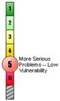
Black Lake Watershed
Watersheds with More Serious Water Quality Problems
--Watersheds with aquatic conditions well below State or
Tribal water quality goals that have serious problems
exposed by other indicators.
Watersheds with Lower Vulnerability to Stressors --
Watersheds where data suggest pollutants or other
stressors are low, and, therefore there exists a lower
potential for future declines in aquatic health. Actions
to prevent declines in aquatic conditions in these
watersheds are appropriate but at a lower priority than
in watersheds with higher vulnerability.
CRITERIA
0. National Watershed Characterization (Data Layer
0)
1. Assessed Rivers Meeting All Designated Uses
Set In State/Tribal Water Quality Standards 1996/1998
Using Latest State Information Reported
2. Fish and Wildlife Consumption Advisories
1997
3. Indicators of Source Water Condition for
Drinking Water Systems 1990-1997
3a. River and Lakes Supporting Drinking Water Uses
1994/1996 3b. Surrogates of Source Water Condition
1991-1996 3c. Occurence of Chemicals in Surface and
Ground Waters that are Regulated in Drinking Water
1990-1997
4. Contaminated Sediments 1980-1993
5. Ambient Water Quality Data - Four Toxic
Pollutants 1990-1997
6. Ambient Water Quality Data - Four Conventional
Pollutants 1990-1997
7. Wetland Loss Index 1982-1992;
1780-1980
7a. Wetland Loss Measured by National Wetlands
Iinventory 1982-1992 7b. Wetland Loss Measured by
National Wetlands Inventory 1780-1980s
8. Aquatic/Wetland Species at Risk 1996
9. Pollutant Loads Discharged Above Permitted
Limits - Toxic Pollutants 1996, 1997
10. Pollutant Loads Discharged Above Permitted
Limits - Conventional Pollutants 1996,
1997
11. Urban Runoff Potential 1990
12. Index of Agricultural Runoff Potential
(Based Upon Nitrogen, Sediment and Pesticide)(1990- 1995)
12a. Potential Pesticide Runoff from Farm Fields
12b. Potential Nitrogen Runoff from Farm Fields
1990-1995
12c. Sediment Delivery to Rivers and Streams
from Cropland and Pastureland 1990-1995
13. Population Change 1980-1990
14. Hydrologic Modification Caused by Dams,
1995-1996
15. Estuarine Pollution Susceptibility
Index Based Upon Pollution Loads and Pollution Retention
Characteristics of Estuaries, 1989-1991
|